Urban Living in Jacksonville: St. Johns Park
Metro Jacksonville takes a stroll through St. Johns Park.
The extension of a streetcar line in 1908 from downtown Jacksonville to Ortega, greatly facilitated growth along the westside of the St. Johns River during the early 20th century. St. Johns Park was one of several major subdivisions established as a result of this infrastructure investment.
Covering a large area between Herschel Street and Cassat Avenue, St. Johns Park was originally established by the Ernest L. Hill Realty Company of 235 West Forsyth Street. Located just south of Fishweir Creek and built around the Atlantic Coast Line's railroad between Jacksonville and Palatka, Hill promoted his segregated 42-block development as having wide streets, beautiful trees, attractive homes, and being far away from Jacksonville's black neighborhoods. Perspective buyers were encouraged to invest $10 cash and $5 per month in neighborhood lots, priced at $350 to $600 each, and watch them enhance in value.
At the time, other than St. Johns Avenue, all of the neighborhood's east-west streets were numbered. Branching off from Herschel Street, St. Johns Avenue provided connectivity between the neighborhood, Avondale, Lake Shore and Orange Park.

Neighborhood map from Ernest L. Hill Realty Company. Courtesy of the Jacksonville Historical Society.
During the neighborhood's early years, the majority of development was concentrated along the blocks sandwiched between the Herschel Street streetcar line and the Atlantic Coast Line Railroad. As the neighborhood and other nearby subdivisions, such as Lakeside Park and Fairfax Manor, came online, Herschel Street developed into a walkable commercial district between Fishweir Creek and San Juan Avenue. Connectivity to downtown was provided by streetcars running every 30 minutes. In 1925, St. Johns Park, east of the railroad tracks, was annexed into the City of Jacksonville.
Following World War II, major highway projects and mid-20th century retailing trends in the area radically altered this development pattern. In 1960, the Jacksonville Expressway Authority completed the Roosevelt Expressway, which severed St. Johns Park in half. Named for President Franklin D. Roosevelt, the highway was originally designed as a bypass system around older westside neighborhoods, built partially to freeway standards between downtown and Orange Park.

Early residences developed by the Ernest L. Hill Realty Company. Courtesy of the Jacksonville Historical Society.
That same year, Robert H. Jacobs, developer of the Universal-Marion Building and Ivey's Department Store complex in downtown Jacksonville, announced his intentions to build a $2.5 million shopping center just south of St. Johns Park. During the mall's 1961 opening day ceremony, Jacobs told shoppers that his Roosevelt Mall was something more than just another shopping center. Indeed, Jacobs had constructed what was considered an ultimate shopping center of the era, featuring pools at either end, both containing a pair of swans, and a forty-five-foot abstract sculpture created by Andre Bloc of Paris.
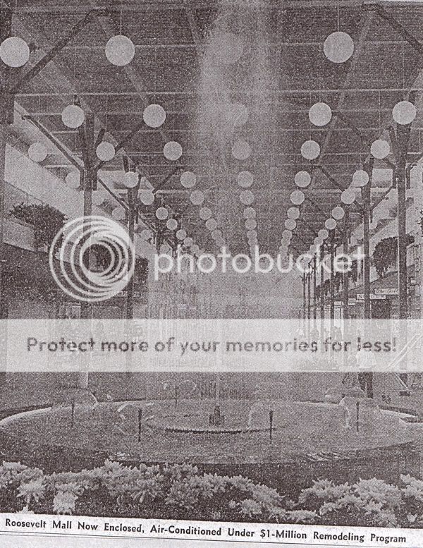
Inside Roosevelt Mall after it was enclosed in 1968. Courtesy of the Florida Times-Union.
These investments, along with the expansion of Blanding Boulevard (former St. Johns Avenue/Orange Park Road), resulted in significant commercial development along and between these thoroughfares.
After 60 years, Jacksonville's outward growth has long moved on from this early 20th century streetcar suburb. Nevertheless, St. Johns Park still retains many of the amenities originally promoted and marketed by Ernest L. Hill. Take a look for yourself!
Next Page: St. Johns Park neighborhood photo tour
Herschel Street Corridor
Herschel Street is the commercial epicenter of early 20th century St. Johns Park and nearby neighborhoods in the vicinity. It is home to several restaurants, cafes, offices and boutique retail services. Between 1908 and 1936, it was served by a streetcar line connecting the area with downtown Jacksonville. Today, this former streetcar corridor is a linear park.


Residential St. Johns Park - East
St. Johns Park between Herschel Street and Roosevelt Boulevard still maintains its original early 20th century charm.


Roosevelt/CSX A-Line Corridor
The CSX A-Line was built by the Jacksonville, Tampa and Key West Railway during the early 1880s. It was acquired by Henry Plant in 1899 and the Plant System was taken over by the Atlantic Coast Line Railroad in 1902. During the mid-20th century, Roosevelt Boulevard was built adjacent to the railroad, stimulating autocentric commercial development through St. Johns Park.


Residential St. Johns Park - West
The west side of St. Johns Park remained sparesly developed prior to World War II. It remained outside of Jacksonville's city limits until the city's consolidation with Duval County in 1968.


Blanding Boulevard/Cassat Avenue/Park Street
Other major roadways penetrating or bordering the westside of the original St. Johns Park neighborhood, include Blanding Boulevard, Cassat Avenue and Park Street.
Blanding Boulevard


Cassat Avenue


Park Street


Article by Ennis Davis, AICP. Contact Ennis at edavis@moderncities.com
Covering a large area between Herschel Street and Cassat Avenue, St. Johns Park was originally established by the Ernest L. Hill Realty Company of 235 West Forsyth Street. Located just south of Fishweir Creek and built around the Atlantic Coast Line's railroad between Jacksonville and Palatka, Hill promoted his segregated 42-block development as having wide streets, beautiful trees, attractive homes, and being far away from Jacksonville's black neighborhoods. Perspective buyers were encouraged to invest $10 cash and $5 per month in neighborhood lots, priced at $350 to $600 each, and watch them enhance in value.
At the time, other than St. Johns Avenue, all of the neighborhood's east-west streets were numbered. Branching off from Herschel Street, St. Johns Avenue provided connectivity between the neighborhood, Avondale, Lake Shore and Orange Park.
Neighborhood map from Ernest L. Hill Realty Company. Courtesy of the Jacksonville Historical Society.
During the neighborhood's early years, the majority of development was concentrated along the blocks sandwiched between the Herschel Street streetcar line and the Atlantic Coast Line Railroad. As the neighborhood and other nearby subdivisions, such as Lakeside Park and Fairfax Manor, came online, Herschel Street developed into a walkable commercial district between Fishweir Creek and San Juan Avenue. Connectivity to downtown was provided by streetcars running every 30 minutes. In 1925, St. Johns Park, east of the railroad tracks, was annexed into the City of Jacksonville.
Following World War II, major highway projects and mid-20th century retailing trends in the area radically altered this development pattern. In 1960, the Jacksonville Expressway Authority completed the Roosevelt Expressway, which severed St. Johns Park in half. Named for President Franklin D. Roosevelt, the highway was originally designed as a bypass system around older westside neighborhoods, built partially to freeway standards between downtown and Orange Park.
Early residences developed by the Ernest L. Hill Realty Company. Courtesy of the Jacksonville Historical Society.
That same year, Robert H. Jacobs, developer of the Universal-Marion Building and Ivey's Department Store complex in downtown Jacksonville, announced his intentions to build a $2.5 million shopping center just south of St. Johns Park. During the mall's 1961 opening day ceremony, Jacobs told shoppers that his Roosevelt Mall was something more than just another shopping center. Indeed, Jacobs had constructed what was considered an ultimate shopping center of the era, featuring pools at either end, both containing a pair of swans, and a forty-five-foot abstract sculpture created by Andre Bloc of Paris.
Inside Roosevelt Mall after it was enclosed in 1968. Courtesy of the Florida Times-Union.
These investments, along with the expansion of Blanding Boulevard (former St. Johns Avenue/Orange Park Road), resulted in significant commercial development along and between these thoroughfares.
After 60 years, Jacksonville's outward growth has long moved on from this early 20th century streetcar suburb. Nevertheless, St. Johns Park still retains many of the amenities originally promoted and marketed by Ernest L. Hill. Take a look for yourself!
Next Page: St. Johns Park neighborhood photo tour
Herschel Street Corridor
Herschel Street is the commercial epicenter of early 20th century St. Johns Park and nearby neighborhoods in the vicinity. It is home to several restaurants, cafes, offices and boutique retail services. Between 1908 and 1936, it was served by a streetcar line connecting the area with downtown Jacksonville. Today, this former streetcar corridor is a linear park.
Residential St. Johns Park - East
St. Johns Park between Herschel Street and Roosevelt Boulevard still maintains its original early 20th century charm.
Roosevelt/CSX A-Line Corridor
The CSX A-Line was built by the Jacksonville, Tampa and Key West Railway during the early 1880s. It was acquired by Henry Plant in 1899 and the Plant System was taken over by the Atlantic Coast Line Railroad in 1902. During the mid-20th century, Roosevelt Boulevard was built adjacent to the railroad, stimulating autocentric commercial development through St. Johns Park.
Residential St. Johns Park - West
The west side of St. Johns Park remained sparesly developed prior to World War II. It remained outside of Jacksonville's city limits until the city's consolidation with Duval County in 1968.
Blanding Boulevard/Cassat Avenue/Park Street
Other major roadways penetrating or bordering the westside of the original St. Johns Park neighborhood, include Blanding Boulevard, Cassat Avenue and Park Street.
Blanding Boulevard
Cassat Avenue
Park Street
Article by Ennis Davis, AICP. Contact Ennis at edavis@moderncities.com